
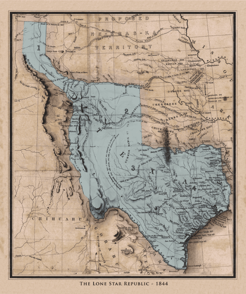
| Invariably, when we post an old Texas map on any social media, a member of the woke brigade will comment something like, “All that land was stolen from Mexico!” I don’t blame them. They are only parroting what they were taught. The problem is no one ever gave them the context in which Texas became Texas. So I have endeavored to provide that context in the fewest words possible. 417 according to the word-count gizmo. Here it is: In the beginning there was land. Then people came. Then other people came and pushed them out. Then still more people came and pushed those people out. This continued in North America for about 15,000 years. Notably, in 1519, a tribe called Spaniards took much land from the Mexica (pronounced Meh-SHE-ca). You probably call them Aztecs. This was done with the aid of tribes from whom the Mexica had previously taken land. Such is life. About 300 years later, the tribe called Spaniards invited Anglo tribesmen to settle in the far north of their American lands. They did this because the response from their own tribesmen to settling there had been, “No way!” Only it was said in Spanish, which they call Espanol. While the Anglo tribesmen were getting settled, the Spaniards born in North America broke away politically from the Spaniards born in Spain. They adopted a constitution much like that of the United States. The Anglo tribesmen were pleased, as that’s where most of them were from, and all people like familiarity. About a dozen years later, a man called Santa Anna came to power. He didn’t like that constitution, so he tore it up. The northern states of Mexico, including the one called Texas where Anglo tribesmen were the majority, said, “Hell no, Santa Anna! We didn’t sign up for this.” That statement was bilingual. Santa Anna marched north and crushed opposition in all the northern Mexican states. Except for Texas, where his campaign of ethnic cleansing did not go as planned. The people who beat him set up a republic. That was 1836. This map shows the borders they claimed. And in spite of the odds against them, they were able to hold those borders until 1845, when they joined the United States. That’s when the United States and Mexico had a fight. Mexico said the border was the Nueces. The United States said it was the Rio Grande. And even though European military experts predicted the United States would lose badly, the US flag was hoisted in Mexico City. In exchange for peace, a big hunk of cash, and the cancellation of its US debts, Mexico agreed the Rio Grande would be the border and gave up claim to New Mexico, Arizona, California, and other western lands. These were lands Mexico had mostly held in name only since separating from the tribe called Spaniards. That was in 1848. It was very good for Mexico’s finances, but very bad for Mexico’s pride. That’s the context in words. Lt. Emory’s 1844 map provides visual context. Here’s another Click below to learn why it was produced. It’s an interesting story. |
Categories: Texas history, Texas Maps